Impact assessment
Impact assessment is a systematic process used to evaluate the potential or realized effects of a project, policy, or intervention on its surrounding environment, economy, and society. It involves identifying, predicting, and analyzing both positive and negative outcomes to ensure that decisions are informed by a comprehensive understanding of their consequences. In sectors such as agriculture, environmental conservation, and social development, impact assessments help to measure the effectiveness of interventions, guide resource allocation, and improve future planning. By utilizing qualitative and quantitative data, this process enables stakeholders to assess the sustainability, scalability, and relevance of initiatives while mitigating risks and enhancing benefits. Modern impact assessments increasingly integrate geospatial, remote sensing, and data analytics tools to offer more precise, real-time insights, thereby supporting evidence-based decision-making and optimizing long-term results for communities and ecosystems.
Urban Sprawl and Adverse Impacts on Agricultural Land
Changes (2005 – 2016) in
Hyderabad,Telangana
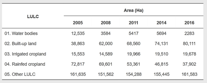
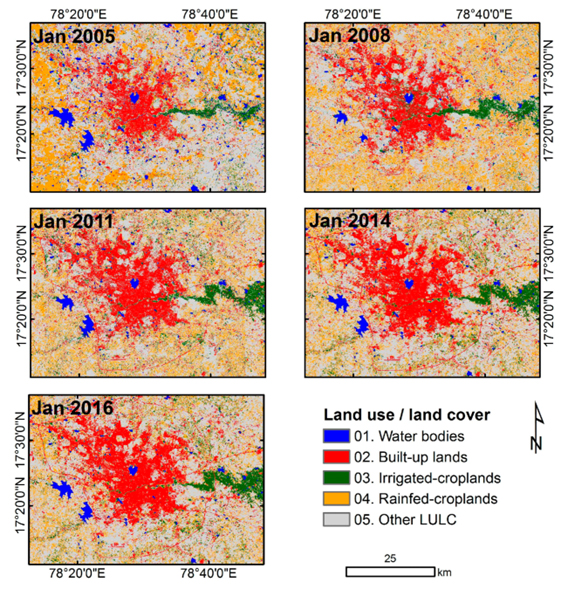
Many Indian capitals are rapidly becoming megacities due to industrialization and rural–urban emigration. Land use within city boundaries has changed dynamically, accommodating development while replacing traditional land-use patterns. Using Landsat-8 and IRS-P6 data, this study investigated land-use changes in urban and peri-urban Hyderabad and their influence on land-use and land-cover. Advanced methods, such as spectral matching techniques with ground information were deployed in the analysis. From 2005 to 2016, the wastewater-irrigated area adjacent to the Musi river increased from 15,553 to 20,573 hectares, with concurrent expansion of the city boundaries from 38,863 to 80,111 hectares. Opportunistic shifts in land-use, especially related to wastewater-irrigated agriculture, emerged in response to growing demand for fresh vegetables and urban livestock feed, and to easy access to markets due to the city’s expansion. Validation performed on the land-use maps developed revealed 80–85% accuracy. read more ...
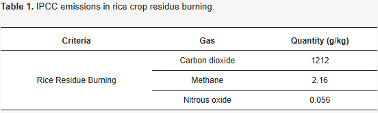
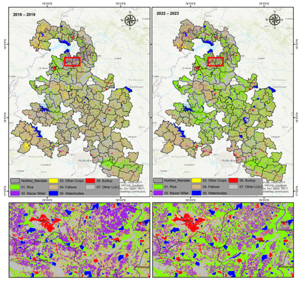
Geospatial Analysis of Crop Residue Burn Areas and Their Dates for Emission Mitigation Strategies
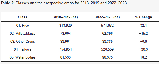
Changes (2018–2019 to 2022–2023) in
Kaleshwaram ,Telangana
Mitigating the environmental impact of agricultural practices, particularly intensive rice farming, is critical in the face of climate change. This study focuses on mapping rice residue burn areas and their dates while estimating the greenhouse gas (GHG) emissions associated with residue burning and rice cultivation. By using Sentinel-2 satellite imagery, machine learning algorithms, and ground truth data, we analyzed changes in rice cultivation patterns before and after the Kaleshwaram intervention. The Near-Infrared Region (NIR) band was instrumental in accurately identifying residue burn areas and pinpointing burn dates, enabling timely alerts for decision-makers to act. Detailed quantifications of CO2, CH4, and N2O emissions from crop residue burning, alongside methane emissions from rice cultivation, highlight the significant contribution of these practices to overall GHG emissions. Key findings reveal a significant 82.1% increase in rice cultivation area from 2018–2019 to 2022–2023, accompanied by a worrying rise in residue burning, with some regions experiencing up to a 276% increase in burn areas. This research not only reveals the dual challenges of residue burning and GHG emissions but also emphasizes the importance of integrating precise burn date monitoring with emission data. The findings provide a strong foundation for implementing sustainable crop residue management strategies and developing informed policies to mitigate the adverse environmental effects of rice farming. read more ...