Responsive image

Natural Resource Management (NRM)

Natural Resource Management (NRM) technologies encompass a diverse set of tools and innovations aimed at the sustainable use and conservation of natural resources. These include Geographic Information Systems (GIS) for spatial analysis, remote sensing for monitoring land cover changes, precision agriculture for efficient farming practices, and conservation agriculture methods to maintain soil health. Biotechnological advances, renewable energy sources, and waste management technologies also contribute to sustainable resource use. NRM technologies play a pivotal role in addressing global challenges by promoting responsible land use, efficient water management, and sustainable agricultural practices.

Responsive image

Focus Areas:

Within our cluster, we emphasize several focus areas to advance agricultural knowledge and enhance decision-making:

   Crop and LULC mapping: We are experts in mapping crop type, croplands, cropping patterns, crop intensity and Land Use and Land Cover (LULC) utilising satellite imagery, ground data and machine learning algorithms.

  Crop stress and biophysical parameter analysis: We employ hyperspectral image analysis and spectral matching techniques to extract information on crop stresses and biophysical parameters, aiding in early detection and mitigation.

   Crop yield prediction: Leveraging diverse data sources, such as satellite imagery and ground sensors, we develop models and techniques for accurate crop yield prediction at the field level. Integrating crop modelling with remote sensing to estimate yield at various administrative levels.

   Spectral variability analysis: Through machine learning algorithms, we gain insights into spectral variability due to crop traits, supporting trait selection and crop management decisions.

   Proximal and remote sensing integration: We leverage Internet of Things (IoT)-based platforms and high-resolution remote sensing imagery to link proximal and remote sensing for field phenotyping.

   Acquisition of high-resolution imagery: Using industry-standard unmanned aerial vehicles (UAVs) equipped with well-calibrated sensors, we acquire very high spatial and temporal resolution imagery for precise monitoring and analysis.

  Trait characteristics of crop varieties: We utilize spectral libraries, genetic meta-information, and breeding trials to characterize the traits of crop varieties, facilitating targeted breeding efforts.

   Typology of crop production environments: We identify factors contributing to yield gaps and address them by understanding the typology of crop production environments.

   Pest and disease hotspots: Through geospatial analysis, we identify hotspots and endemic areas prone to pests and diseases, enabling targeted management strategies.

   Hyperspectral data repository: We maintain a repository of hyperspectral point data and imagery, including spectral libraries of screened germplasm collections at ICRISAT genebank.

   Spatial and Non-spatial data: We handle spatial data involving geographic or geometric attributes, often managed with Geographic Information Systems (GIS) and Non-spatial data, typically tabular, involves statistical analysis, machine learning, and data visualization techniques. Further integrating non-spatial data with spatial for better analysis.

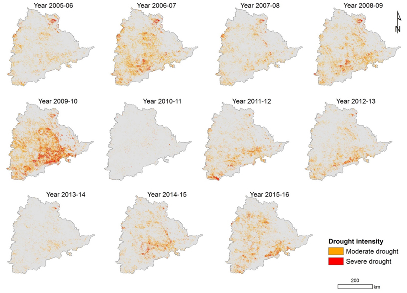
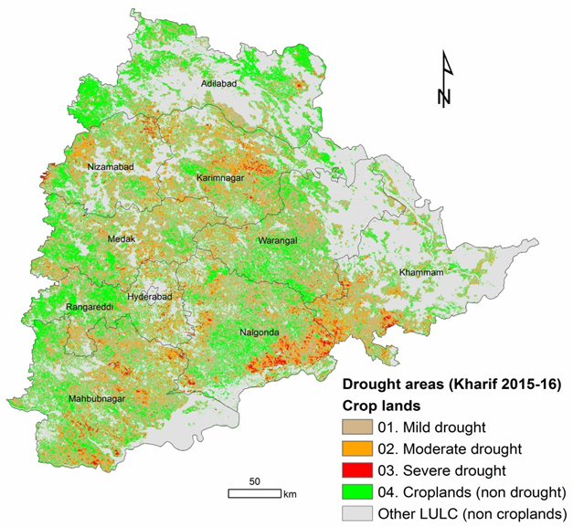
Temporal drought monitoring

Case Study (2015-16) - State of Telangana

  Farmers can utilize temporal drought monitoring to anticipate and respond to drought conditions, enabling timely adjustments to irrigation and crop management strategies to mitigate losses.

  Policymakers can leverage drought monitoring data to implement effective drought management policies, allocate resources efficiently, and support affected communities through timely interventions.

Responsive image
Responsive image

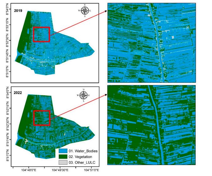
Mapping Shrimp farming in Myanmar

Shrimp farming and exporting is the main income source for the southern coastal districts of the Mekong Delta. Monitoring these shrimp ponds is helpful in identifying losses incurred due to natural calamities like floods, sources of water pollution by chemicals used in shrimp farming, and changes in the area of cultivation with an increase in demand for shrimp production. Satellite imagery, which is consistent with good spatial resolution and helpful in providing frequent information with temporal imagery, is a better solution for monitoring these shrimp ponds remotely for a larger spatial extent. The shrimp ponds of Cai Doi Vam township, Ca Mau Province, Viet Nam, were mapped using DMC-3 (TripleSat) and Jilin-1 high-resolution satellite imagery for the years 2019 and 2022. The 3 m spatial resolution shrimp pond extent product showed an overall accuracy of 87.5%, with a producer’s accuracy of 90.91% (errors of omission = 11.09%) and a user’s accuracy of 90.91% (errors of commission = 11.09%) for the shrimp pond class. It was noted that 66 ha of shrimp ponds in 2019 were observed to be dry in 2022, and 39 ha of other ponds had been converted into shrimp ponds in 2022. The continuous monitoring of shrimp ponds helps achieve sustainable aquaculture and acts as crucial input for the decision makers for any interventions. read more ...

Responsive image

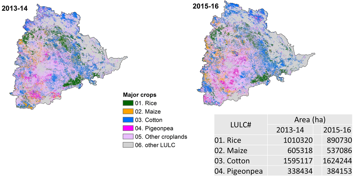
Temporal Cropland Changes

Case Study (2015-16) - State of Telangana
Responsive image
Responsive image

Headquarters

ICRISAT-iHub-GBDS

Mailing Address

ICRISAT-iHub-GBDS Patancheru,Hyderabad Telangana,India

Copyright @ Remote Sensing and GIS Unit ICRISAT