Land use and land cover (LULC)
Land use and land cover (LULC) are critical components in understanding the interactions between human activities and the environment. Land use refers to how humans utilize the land for activities such as agriculture, urbanization, forestry, and industry, while land cover describes the physical and biological features that dominate the Earth's surface, such as forests, water bodies, grasslands, and urban structures. Changes in LULC can significantly impact the environment by altering ecosystems, biodiversity, hydrological cycles, and climate patterns. For instance, deforestation and urban expansion often lead to habitat loss, increased greenhouse gas emissions, and disruptions in natural water filtration processes. Conversely, reforestation and sustainable land management practices can improve carbon sequestration, enhance biodiversity, and support climate change mitigation. Monitoring LULC changes through remote sensing and geospatial analysis is crucial for managing natural resources, planning sustainable land use strategies, and understanding the long-term impacts of human activities on the environment.
Focus Areas:
Within our cluster, we emphasize several focus areas to advance agricultural knowledge and enhance decision-making:
-
1.Key Applications
- Urban Planning: Assessing urban expansion and infrastructure needs.
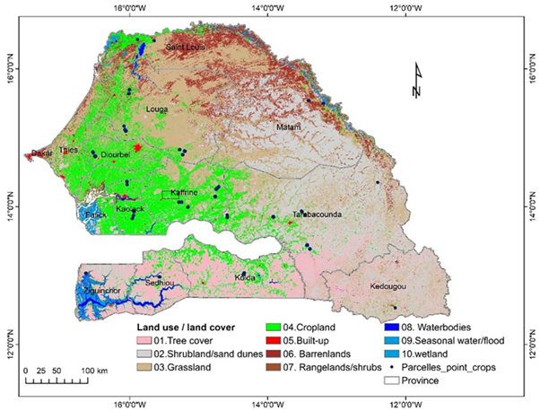
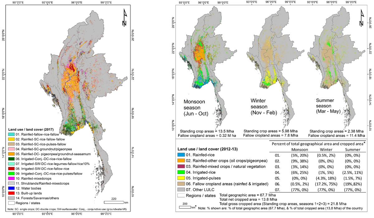
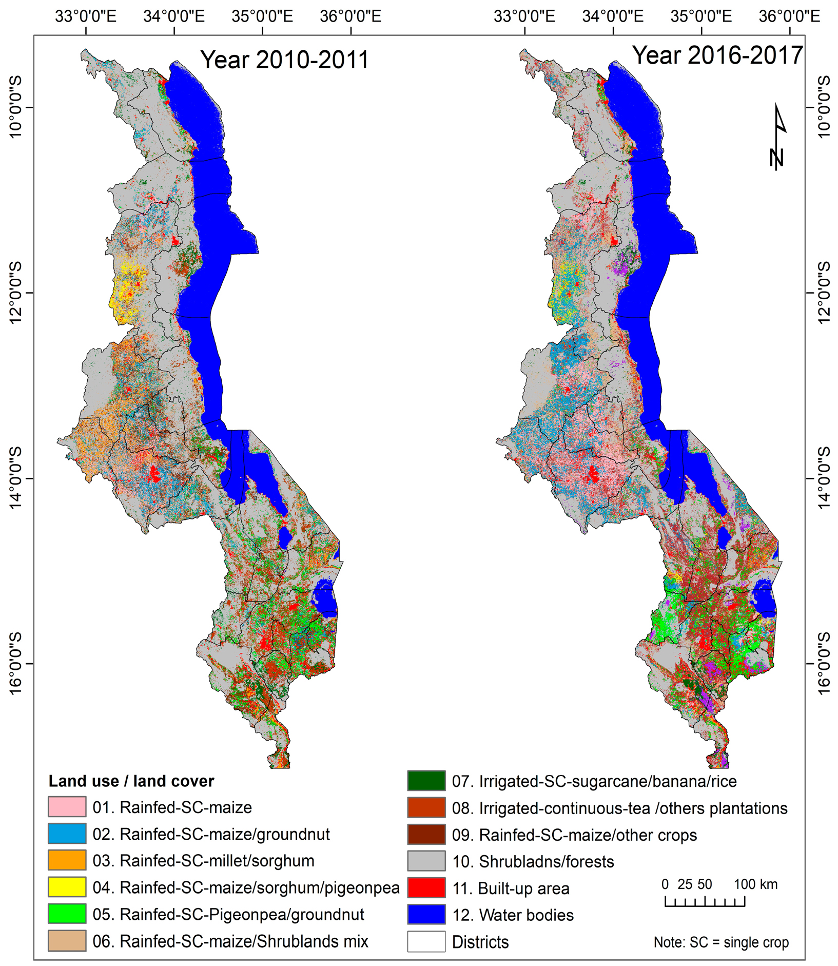
- Agriculture: Mapping croplands, crop yield potential, and irrigation patterns.
- Forestry: Monitoring deforestation, afforestation, and biodiversity.
- Water Resources: Analyzing wetland dynamics and watershed management.
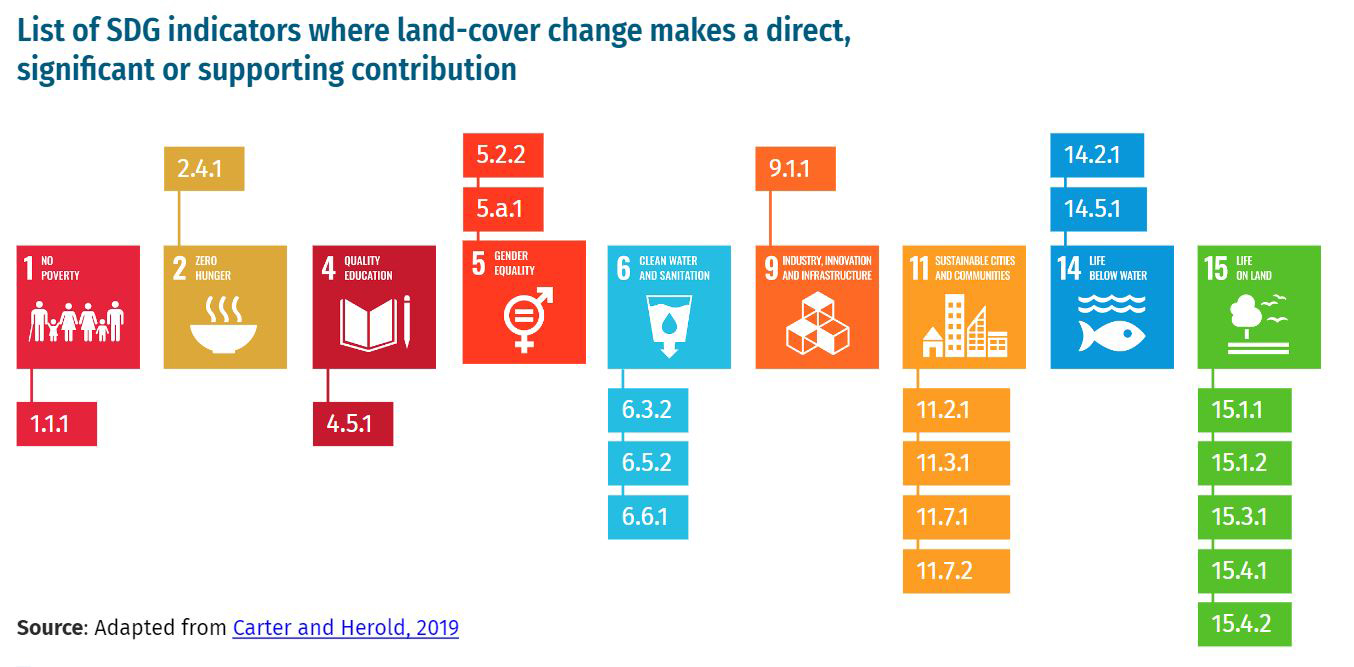
- Disaster Management: Identifying areas at risk of floods, landslides, or droughts. 2. Environmental Impacts of LULC Changes
- Climate Change:Alteration in carbon sinks (deforestation) and increased greenhouse gas emissions.
- Biodiversity Loss: Habitat fragmentation and species extinction.
- Soil Degradation:Increased desertification and loss of arable land.
- Water Cycle Disruption: Reduced infiltration and increased surface runoff, leading to water scarcity or floods. 3. Technologies in LULC Mapping
- Remote Sensing: Satellite imagery for large-scale monitoring (e.g., Landsat, Sentinel).
- GIS Tools: Spatial analysis to map, visualize, and model LULC changes.
- Machine Learning Models: Automated classification of LULC categories from high-resolution imagery. 4. Strategies for Sustainable LULC Management
- Afforestation and Reforestation: Rebuilding carbon sinks and biodiversity.
- Integrated Land Use Planning: Balancing ecological, social, and economic needs.
- Conservation Policies: Protecting wetlands, forests, and other critical habitats.
- Community Engagement: Involving local stakeholders in decision-making. 5. Focus Areas for Research and Action
- Ecosystem Services: Quantifying the benefits provided by different land covers.
- LULC and Carbon Footprint: Analyzing how changes impact carbon emissions.
- Urban Heat Islands: Understanding the impact of urban sprawl on local climates.
- Water-Energy-Food Nexus: Balancing competing demands in a changing environment.
Mapping cropping systems in Senegal
Dryland cropping in different Land uses of Senegal using Sentinel-2 and hybrid ML method.
In rainfed and dryland agricultural areas with smallholder farms (less than 2 ha), crop diversity is high due to farmers' decisions and local climatic conditions, leading to a complex spatial–temporal distribution of crops. Monitoring and mapping crops is crucial for food security and implementing agricultural support programs. This study aims to map crop types across Senegal using Sentinel-2 satellite imagery and the limited ground reference data available, which has been increasing recently. The study compares conventional supervised classification algorithms to unsupervised classification algorithms using high-resolution satellite imagery. Crop type classification for 2020 in Senegal employed supervised machine learning algorithms, including Classification and Regression Trees (CART), Random Forest (RF), and Support Vector Machine (SVM) on the Google Earth Engine (GEE) cloud platform, and the unsupervised Iso-clustering classification algorithm with Spectral Matching Techniques (SMTs). Due to limited ground data, supervised classifiers achieved 45-55% accuracy, whereas the unsupervised semi-automatic approach achieved over 75% accuracy. The study indicates that supervised classifiers' performance depends on ground data quantity, while SMT shows good performance even with limited ground data. This SMT approach is valuable for classifying crop types in dryland areas with smallholder farms and diverse cropping patterns.read more ...

Mapping cropping systems in Myanmar
Mapping cropland fallow areas in myanmar to scale up sustainable intensification of pulse crops in the farming system
Cropland fallows are the next best-bet for intensification and extensification, leading to increased food production and adding to the nutritional basket. The agronomical suitability of these lands can decide the extent of usage of these lands. Myanmar’s agricultural land (over 13.8 Mha) has the potential to expand by another 50% into additional fallow areas. These areas may be used to grow short-duration pulses, which are economically important and nutritionally rich, and constitute the diets of millions of people as well as provide an important source of livestock feed throughout Asia. Intensifying rice fallows will not only improve the productivity of the land but also increase the income of the smallholder farmers. The enhanced cultivation of pulses will help improve nutritional security in Myanmar and also help conserve natural resources and reduce environmental degradation. The objectives of this study was to use remote sensing methods to identify croplands in Myanmar and cropland fallow areas in two important agro-ecological regions, delta and coastal region and the dry zone. The study used moderate-resolution imaging spectroradiometer (MODIS) 250-m, 16-day normalized difference vegetation index (NDVI) maximum value composite (MVC), and land surface water index (LSWI) for one 1 year (1 June 2012–31 May 2013) along with seasonal field-plot level information and spectral matching techniques to derive croplands versus cropland fallows for each of the three seasons: the monsoon period between June and October; winter period between November and February; and summer period between March and May. The study showed that Myanmar had total net cropland area (TNCA) of 13.8 Mha. Cropland fallows during the monsoon season account for a meagre 2.4% of TNCA. However, in the winter season, 56.5% of TNCA (or 7.8 Mha) were classified as cropland fallows and during the summer season, 82.7% of TNCA (11.4 Mha) were cropland fallows. The producer’s accuracy of the cropland fallow class varied between 92 and 98% (errors of omission of 2 to 8%) and user’s accuracy varied between 82 and 92% (errors of commission of 8 to 18%) for winter and summer, respectively. Overall, the study estimated 19.2 Mha cropland fallows from the two major seasons (winter and summer). Out of this, 10.08 Mha has sufficient moisture (either from rainfall or stored soil water content) to grow short-season pulse crops. This potential with an estimated income of US$ 300 per hectare, if exploited sustainably, is estimated to bring an additional net income of about US$ 1.5 billion to Myanmar per year if at least half (5.04 Mha) of the total cropland fallows (10.08 Mha) is covered with short season pulses.read more ...

Mapping cropping systems in Malawi
Monitoring Changes in the Cultivation of Pigeonpea and Groundnut in Malawi Using Time Series Satellite Imagery for Sustainable Food Systems
Malawi, in south-eastern Africa, is one of the poorest countries in the world. Food security in the country hinges on rainfed systems in which maize and sorghum are staple cereals and groundnut and pigeonpea are now major grain legume crops. While the country has experienced a considerable reduction in forest lands, population growth and demand for food production have seen an increase in the area dedicated to agricultural crops. From 2010, pigeonpea developed into a major export crop, and is commonly intercropped with cereals or grown in double-up legume systems. Information on the spatial extent of these crops is useful for estimating food supply, understanding export potential, and planning policy changes as examples of various applications. Remote sensing analysis offers a number of efficient approaches to deliver spatial, reproducible data on land use and land cover (LULC) and changes therein. Moderate Resolution Imaging Spectroradiometer (MODIS) products (fortnightly and monthly) and derived phenological parameters assist in mapping cropland areas during the agricultural season, with explicit focus on redistributed farmland. Owing to its low revisit time and the availability of long-term period data, MODIS offers several advantages, e.g., the possibility of obtaining cloud-free Normalized Difference Vegetation Index (NDVI) profile and an analysis using one methodology applied to one sensor at regular acquisition dates, avoiding incomparable results. To assess the expansion of areas used in the production of pigeonpea and groundnut resulting from the release of new varieties, the spatial distribution of cropland areas was mapped using MODIS NDVI 16-day time-series products (MOD13Q1) at a spatial resolution of 250 m for the years 2010–2011 and 2016–2017. The resultant cropland extent map was validated using intensive ground survey data. Pigeonpea is mostly grown in the southern dry districts of Mulanje, Phalombe, Chiradzulu, Blantyre and Mwanza and parts of Balaka and Chikwawa as a groundnut-pigeonpea intercrop, and sorghum-pigeonpea intercrop in Mzimba district. By 2016, groundnut extent had increased in Mwanza, Mulanje, and Phalombe and fallen in Mzimba. The result indicates that the area planted with pigeonpea had increased by 29% (75,000 ha) from 2010–2011 to 2016–2017. Pigeonpea expansion in recent years has resulted from major export opportunities to Asian countries like India, and its consumption by Asian expatriates all over the world. This study provides useful information for policy changes and the prioritization of resources allocated to sustainable food production and to support smallholder farmers.read more ...
